Home Blog Page 70

Anza Borrego-Galleta Meadows Sculptures

Galleta Meadows Sculptures

Directions: Most of the sculptures are located north of Christmas Circle, the roundabout in the center of Borrego Springs along Borrego Springs road. There are others south of Christmas Circle along Borrego Springs Road before you get to Yaqui Pass Road.  You can get a free map of all the sculptures at the Visitor Center.

Desert Serpent
Desert Serpent

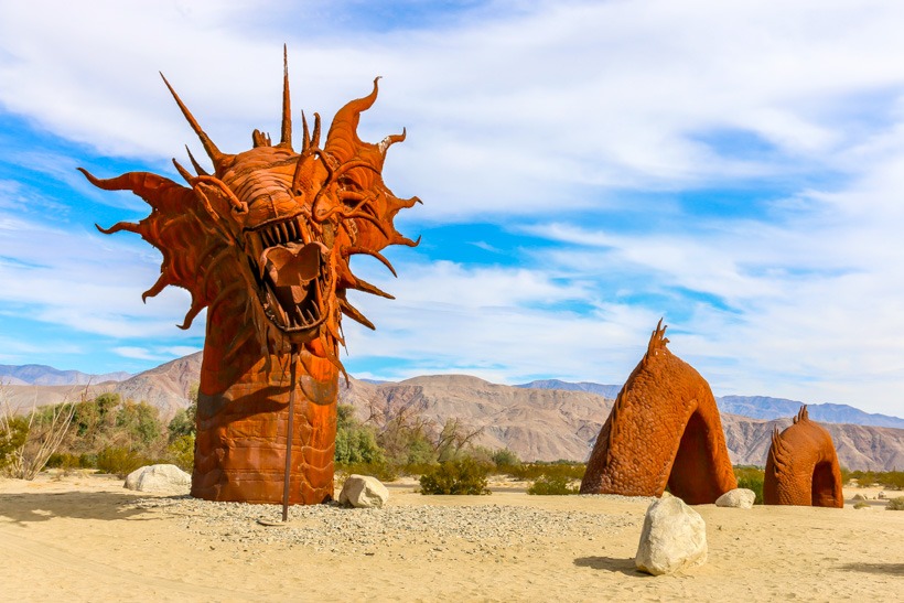
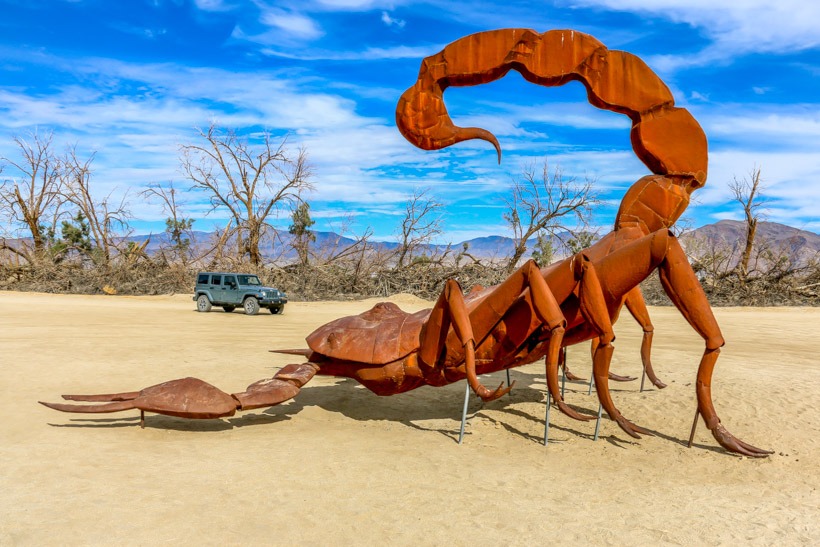
Site Location and Description: This sculpture garden in Anza Borrego State Park is a truly amazing desert find.  In Galleta Meadows there are over 130 large metal sculptures to enjoy.  From the paved road you can easily drive on dirt roads to get near each of the life-sized sculptures. There are creatures that roamed the Anza Borrego Desert over 6.5 million years ago, as well as sculptures depicting more recent wildlife.

Desert Cricket
Desert Cricket

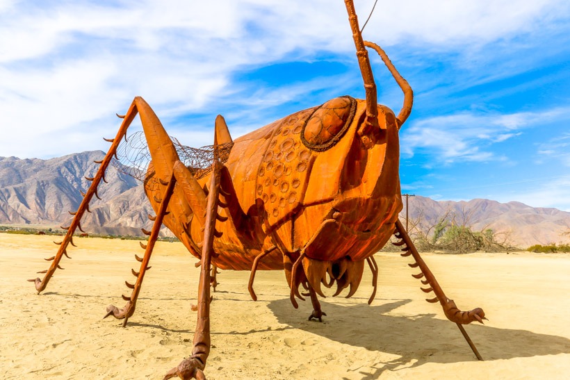
Other interesting Galleta Meadows sculptures include a “Gomphotheres”; a four-tusked elephant-like creature, giant tortoises, “camelops”; the predecessor of today’s camels, a giant sloth, dinosaurs, romping horses, an amazing serpent, and more.  One of the latest creations is a 350-foot sea serpent whose body submerges and emerges from the desert floor. It’s got the head of a dragon and a rattlesnake’s tail.  It cost around $40,000, took four months to craft, and  took another three months to erect in Borrego Springs.  Galleta Meadows is a  great photo opportunity and a fun opportunity for exploration for all ages.

Scorpion and Rubi
Scorpion and Rubi

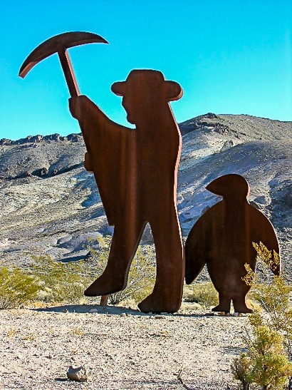
The History of Galleta Meadows:  The late Dennis Avery, of the Avery Label fortune and land owner of approximately three square miles of undeveloped land in Borrego Springs  wanted to create a ‘free-standing art gallery’ on his property.  He met Ricardo Breceda, the  ‘Perris Jurassic Park’ owner/artist/welder based in Perris, California. He commissioned Breceda in 2008 to create a collection of prehistoric creatures.  Since then, the collection has grown to include human figures like a gold miner, farm workers, Native American, Spanish padre, along with popular dinosaurs such as a tyrannosaurus rex, velociraptor, spinosaurus and allosaurus.

Borrego Stardance” courtesy of Gavin Heffernan, Sunchaser Pictures

Anza Borrego-The Narrows

The Narrows Trail head
GPS 33.13072, -116.301549
Elevation  717 ft. to 1,250 ft.
Season Year round: best Oct.-May
Terrain Packed dirt
Difficulty Easy terrain
Required Vehicle 2  wheel drive
Time 10 minutes
Length of Trail 1/2 mile loop

Anza Borrego-A hallway at the Narrows
A “hallway” at the Narrows

Directions:   From Christmas Circle in Borrego Springs, drive 11.5 miles southwest on Borrego Springs Road. Turn right on Route 78 west and drive 4 miles through a dramatic gap between Yaqui Ridge and the Vallecito Mountains. Pull off the road into the trailhead parking area on the south (left) side of the road near mile marker 81.5, just south of Quartz Vein Wash.

Anza Borrego-Bridge at the Narrows
“Bridge” at the Narrows

Site Location and Description: This is a very short, extremely cool hike very close to the trail up  to Calcite mine.  If you are going to the mine, bear left and you will soon arrive at the Narrows.  As in other areas of Anza Borrego, the Narrows offers the visitor spectacular examples of rock formations and sedimentations that are an archeologist’s dream.  This is a super fun, kid friendly hike that winds around through and under mud/rock tunnels and gives everyone plenty to look at, climb up on and under and take photos of.  Reportedly there are pamplets at the beginning of the trail with good information about the geology.  We didn’t see them when we visited, although it could have been because we were really excited about getting into the narrows and exploring.  This is a popular trail so pick your times to explore wisely. TAP Note:  Although we enthusiastically promote exploring the Narrows, we stress that you be very careful, always:  take water, watch the kids, and do not mark or take any rocks.

Crouch under the fallen rock-the Narrows

Pinkham Canyon Trail – Joshua Tree National Park

Pinkham Canyon Road, overland trails, off-road trials, california overland trails, over landing, over land, off-road, off-roading, vehicle supported adventure, Joshua Tree National Park,
GPS- Pinkham Canyon Trail N33  46.75  W115  54.99
Elevation 1,400-3,400 ft.
Season Year round: best Oct.-May
Terrain graded, narrow in sections, loose and sandy in spots
Difficulty Easy to Moderate
Required Vehicle high-clearance 4WD
Time 2 1/2 hours
Length 21.5 miles

Pinkham Canyon Road, overland trails, off-road trials, california overland trails, over landing, over land, off-road, off-roading, vehicle supported adventure, Joshua Tree National Park,
Pinkham Canyon Trail Head

Pinkham Canyon Road, overland trails, off-road trials, california overland trails, over landing, over land, off-road, off-roading, vehicle supported adventure, Joshua Tree National Park,
Heading west on Pinkham Canyon Trail

Directions to Pinkham Canyon Trail: This overland trail begins opposite the Cottonwood Visitor Center on Pinto Basin Road and ends at I-10 Frontage Road exit, 17 miles east of Indio.

Site Location and Description:  This is a beautiful and easy off-road trail that crosses through a sloped bajada and winds through Mojave yuccas to a gap in the Cottonwood Mountains.  Monument mountain can be seen to the north and you’ll drive through the Pinckam Canyon Wash.  There is one side trail down Thermal Canyon.  Again, a beautiful trail worthy of exploration.

Pinkham Canyon Road, overland trails, off-road trials, california overland trails, over landing, over land, off-road, off-roading, vehicle supported adventure, Joshua Tree National Park,
Deep in the Pinkham canyon Joshua Tree National Park

History of Pinkham Canyon Trail: This area was inhabited by the Pinto people; some of the earliest inhabitants of the Southwest.  They used it’s river as a food gathering source.  Evidence has been left behind as rock art scattered throughout the area.  The Cahuilla Indias also roamed this region and used it’s water sources. Look for the mortar holes in the rocks.  Long after the Pinto Valley became a dry basin, prospectors arrived.  They named a peak near Cottonwood Spring at the northeastern end of the trail, Mastodon for it’s shape.  They opened a mine, active from 1910-1930 at the base of Mastodon Peak.  Shafts and some ruins remain.  Moorten’s and Winona Mills were also located in this region.   Miners used the water at Cottonwood Spring for their mills and teamsters transporting supplies in the Pinto Mountains also made use of this water source.

Pinkham Canyon Road, overland trails, off-road trials, california overland trails, over landing, over land, off-road, off-roading, vehicle supported adventure, Joshua Tree National Park,
Foliage in Pinkham Canyon

Click here for more CA off-road, Overlanding trails…..and TAP into Adventure!

Goldwell Open Air Museum & Artist Residency

IMG 0088 2
IMG 0088 2

Goldwell Open Air Museum The Last Supper

GPS N36.890223 W116.833672
Elevation 3,819 ft
Season Year round: best Oct.-May
Terrain Packed dirt
Difficulty Easy
Hours of operation 24/7  no admission fee
Established 2000
Contact Information 1 Golden Street, Rhyolite, NV 89003
702-870-9946
goldwellmuseum.org

Directions: From Beatty, on the 374 approximately 5 miles east of Death Valley National Park.

Goldwell Miner
Tribute to Shorty Harris

Site Description and History:  Goldwell is an outdoor sculpture park created in 2000 by a group of prominent Belgian artists, led by the late Albert Szukalski, who decided he was going to create a self-described  “art situation”in a unique area that would give him freedom of expression and scope.  A place vastly different than their practice spaces in Europe.   The installment is made up  of seven outdoor sculptures that are amazing.  They are large, some colorful, thought provoking, and randomly beautiful.  You will see the sculpture, The Last Supper modeled after Leonardo De Vinci’s painting The Last Supper and Ghost Rider, both created in 2000 by Szukalski by draping plaster-soaked burlap over live models until it dried and stood up on it’s own.  Other works of art include Tribute to Shorty Harris made by Fred Bervoets in tribute to one of the miners whose gold discovery led to the goldrush of 1904.   Dre Peters created a hand-carved female version of Icarus, the boy who flew too close to the sun in Icara….an appropriate sculpture for the desert!  A fun installment is a colorful tile mosaic covered couch originally made for the Children’s Discovery Museum in Las Vegas by Sofie Siegmann.  It was restored and brough to Goldwell Museum in 2007.  Another fun piece out here is The Venus of Nevada, a sculpture made of cinder block based partially on the concept of a pixel (we thought it was Legos).  For more information about the sculptures, contact the museum with the info in the box above.  Ask about the arts festival in October and let us know how you liked it.

This is a truly unique find out in the upper Mohave desert and a nice stop on your way into Death Valley National Park.   The Goldwell open air museum also has a new artist residentcy and artist workspace program in the nearby Red Barn Art Center that houses a feature artist for a month.  (The Adventure Portal called and asked for permission to display photos of the works on this site.  They graciously gave it to us.)

Icara
Icara


Ghost Rider
“Ghost Rider”..going to Rhyolite?

Lady Desert: The Venus of Nevada

Chained to the Earth

Sit Here!
Sit Here!

Death Valley-Scotty’s Castle

Scottys Castle Death Valley
GPS N37.0322   W117 .3415
Elevation 3,000 ft.
Season November- mid April prime. Summer very hot and less tours
Tour Schedule 10:00a.m-3:30pm (varies-call in advance)
Tour length and frequency  50 minutes: tours start every hour except in the summer
Phone number 760-786-2392
Ticket Prices and information $15 adult/ $7.50 child (6-15) or interagency pass holder. Tickets are sold for the day of the tour at the Scotty’s Castle Visitor Center. There may be a two-hour wait for the next available tour during peak visitation periods such as Thanksgiving weekend, the weeks of Christmas, New Year’s Day, and mid-February through April. Visitation is highest between 11:00 am and 3:00 PM.
Address 123 Scottys Castle Rd.  Death Valley Ca 92328 
 Advanced group ticket purchase    www.recreation.gov or 1-877-444-6777 for groups of 15 or more

Guided Tour Scotty's Castle Death Valley
Guided Tour Scotty’s Castle Death Valley

Site Location and Description  The Death Valley Ranch, or Scotty’s Castle is located about 45 miles north of Stovepipe Wells, California, via California State Route 190 to Scotty’s Castle Road, or about a three-hours drive from Las Vegas, Nevada. The only way to see the inside of the Castle is by taking a guided tour. The tour provides the visitor a look into the life and times of the Roaring ’20s and Depression ’30s. It’s archetecture is beautiful, and the story of a wealthy matron’s vacation home and a man-of-mystery’s hideout and getaway is facinating.

Scotty's Castle Death Valley
Scotty’s Castle Death Valley

The History of Scotty’s Castle
Walter Scott or “Death Valley Scotty”, convinced everyone that he had built the castle with money from his rich secret mines in the area. Albert Mussey Johnson actually built the house as a vacation getaway for himself and his wife Bessie. Albert had both the brains and the money while Scotty was the mystery, the cowboy, and the entertainer, who wooed his way into the Johnson’s life and home. Take a living history tour and step back into 1939. The Johnsons’ original furnishings and clothing can still be seen today. Both the Scotty’s Castle Visitor Center and the Castle Museum are currently open year-round, and approximately 100,000 people tour the villa each year. The tour is well done and interesting for both children and adults. It is a good activity to add some variety to your desert explorations.

Piano room Scotty's Castle Death Valley
Piano room Scotty’s Castle Death Valley

Details of Scotty's Castle Death valley
Details of Scotty’s Castle Death valley

Death Valley-Tea Kettle Junction

IMG 1074 1
IMG 1074 1
GPS                 N36 45.61   W117 32.48

Site Location and Description:  Teakettle Junction is located at the junction of Hidden Valley Road and Racetrack Road in Death Valley National Park. This is an unusual site with a sign and an international display of kettles that mark the spot. Each kettle has a message of greeting from the owner, usually indicating where they came from. Some have e-mail addresses encouraging visitors to take a picture of themselves and send it along to them. We saw kettles from the Ukraine, Canada, France….it’s a fun spot to visit. Bring your old kettle with you when you come to add to the collection. By the way, the collection changes as the park rangers collect them when the amount of kettles becomes cumbersome. So each trip to the junction should reveal new treasures.

Teakettle Junction
Teakettle Junction

The History of Tea Kettle Junction

Little is known of the history of the junction. Rumor has it that the kettles were hung to show early settlers that there was water nearby. It is also believed to be good luck to leave a kettle with a message written on or left in it.

Messages on the kettles

kettles at Teakettle junction

Sign up for our newsletter and TAP into Adventure!